
Open house at Wauwatosa City Hall invites public input on
Tuesday from 5:30-7:30
“I heard that the city had changed its plans and will be
saving the woods.” That was among the many comments I myself heard this weekend
in a section of the County Grounds that some have dubbed “Sanctuary Woods.” I
was talking with Dennis, who comes to the County Grounds almost daily to walk his
two large dogs. Unfortunately,
-->
Unfortunately, Dennis had heard something
misleading—perhaps from an article
in the Milwaukee Journal Sentinel—that depended on how “Sanctuary Woods” was
defined.
The current draft of Wauwatosa’s Master
Plan would cut a road through the very spot we were standing, just like the
previous version did. Dennis, like nearly everyone else I met, was surprised
when he looked around at the area that would be destroyed. |
| The pavement on this popular pathway is a legacy of the asylum grounds that formerly occupied the site. This is where the road would go. |
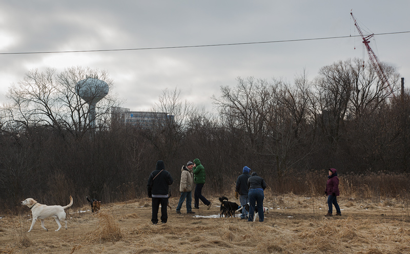
Fortunately, there has been an outpouring of concern about
the fate of the County Grounds as well as the Master Plan itself. On Saturday a
group calling itself Tosa for Good led a guided tour of the area that would be
impacted by the proposed road. Despite a gloomy, overcast day, 50-60 people—including
several city and county officials—endured frigid wind chills to walk the route
of proposed “Scenic Drive.” The organizers had made the impact of the proposal
more vivid by taping off part of the route in a 60-foot wide swath.
 |
| Caution tape indicating the width and route of the proposed road. |
The tape made it clearly visible that
the plan’s proposed 58-ft. wide right-of-way would obliterate a lot of natural
land and require cutting plenty of trees. Virtually everyone who was there and
saw firsthand what’s at stake agreed that the road should not be built.
 |
| Seven-story tall Harwood Place gives a sense of the impact that even taller buildings would have on adjacent woodlands. |
When people are further informed that the proposed plan
allows 10-story buildings to overlook the County Grounds there is universal
astonishment. No one I spoke with wants this to happen.
 |
| The proposed road would cut a swath approximately four times as wide as this unofficial but well used neighborhood trail. |
Starting at 87th Street the tour took the group
east to a section of the grounds rarely included when people discuss “Sanctuary
Woods.” But this combination woodlot and wetland that drains into the Menomonee
River is the most secluded on the County Grounds. A trail well packed by
neighbors skirts the woods on its way to the rest of the grounds. The proposed
road would slice off a huge swath of the woods and create traffic through this
bucolic corner of the grounds and around Harwood Place. However, the people who
live in the adjacent neighborhood have developed an organized campaign that is
generating more citizen interest and investment in the master planning process.
 |
| The proposed road would replace a series of warehouses along the railroad separating the County Grounds from Hoyt Park. |
 |
| This wetland adjacent to “Sanctuary Woods” was isolated when the current roadway into the County Grounds was created. |
Many of the tour participants had never been on the County
Grounds before and no one wanted to miss the now-famous ravine. We entered the
woods and followed the west rim. The packed earth trail indicates how popular
this spot has become. There is apparently widespread agreement that the woods
around the ravine must be saved. In fact, the master plan would protect it.
 |
| One of two stone staircases in bad disrepair that remain from the time this was a retreat for residents of the county asylum. |
However, some who still want to build a road through this
corner of the County Grounds have adopted the name “Sanctuary Woods” to justify
the claim that it is being saved. In other words, the formerly undefined
“Sanctuary Woods” is being defined by some to exclude natural areas that would
be destroyed by the road. If built, a road would severely compromise the land as habitat and setting for
peaceful recreation.
 |
| A lone jogger in the woods along the ravine. |

As the tour passes the second of the stone stairs a couple of children break away to climb down and up again.
Beyond the end of the ravine several trails diverge and head
uphill towards the rear of Ronald McDonald House. There are three meadows in
the former asylum grounds. One is a remnant oak savanna, which is not only rare
but also high quality habitat. The other two are hugely popular with dog
walkers. All three would be destroyed by the road and development proposed in
the plan. Two woodlots that many who use this land consider part of “Sanctuary
Woods” would also be cleared.

The tour grouped around one of the entrances to the woodlot separating two meadows. This woodlot and both meadows are in the path of the proposed road.
The tour turned from the east meadow
and headed back towards 87th Street, covering only half of the area that would be impacted by the
proposed master plan. I returned the following day in order to complete the
walking tour in photographs.
 |
| The meadow in winter |
Humble as it may appear in winter with its matted grasses
and dull colors, this meadow is what I consider to be the heart of “Sanctuary
Woods.” It is spectacular in the summer when decked out
in wildflowers and surrounded by giant oaks and maples; or in autumn when the
leaves turn red and gold. Plus, this is excellent habitat for the birds,
butterflies and small furry creatures that keep it spectacular. Unfortunately, the proposed road would run right through the middle of it.
 |
| The meadow in autumn |
 |
| Dog walkers socializing on edge of County Grounds Park. The proposed road would go through the woodland in the background. |
Sunday was as overcast as Saturday, but warmer. I met dozens
of people. Most of them were out walking dogs of all sizes and breeds. Normally
I keep to myself but this day I stopped frequently to chat. Without exception
everyone I met had heard of the master plan. And all considered the road idea a
mistake at best. Most used spicier language to describe the plan.
 |
| A small creek runs through the woodland, excellent habitat for a variety of reptiles and amphibians. |
A man with a graying beard introduced himself as Tom. He
told me he’d grown up in Wauwatosa and was incensed about the road. He’d seen
plenty of changes over the years and he confessed that he had never been
opposed to the flood detention basins like so many others had been. But this
new master plan was going too far, in his opinion. He proudly whipped out his
cell phone and showed me a photo he’d shot of a buck peering out of the
undergrowth. “At least 6-point,” he said. “Could have been an 8-pointer.”
 |
| Danielle on her daily walk with her two dogs. |
“It makes me angry,” said Danielle forcefully, referring to
the master plan. “There’s so much wildlife here. If they put this road in here
it will drive off the wildlife. Expect coyotes in your backyards killing your
pets!” She explained how careful she was to control her two dogs so that they
wouldn’t cause any harm.
 |
| The proposed road would begin at the roundabout next to the Marriott hotel at Innovation Park and run through this woodlot behind the power plant. |
Two members of the Wauwatosa Common Council had taken the
tour. Second District Alderman John Dubinski spoke with passion about the
grounds. A retired police officer, he recalled fond memories of the County
Grounds and especially the County Asylum buildings when they were still
standing. “Now almost forty years
later it is gone.” He enumerated the losses: beautiful brick buildings; an old
red barn; baseball diamond; soccer fields; “and gone are all of the mature
trees that shaded the area.”
 |
| Alderman John Dubinski: “I am strongly against the proposed road.” |
“I will be
taking my Grandkids for a walk through the wooded area north of the McDonald house,
and taking many photos. It will be good to have a record of history should the
wrong decisions be made.” When I asked specifically about the master plan he
was unequivocal: “I am strongly against the proposed road.”
 |
| I counted eight owls on Sunday and I met two birders who had driven from Iowa to see them. |
In an email after
the tour Third District Alderwoman Nancy Welch summed up the event: “I was
impressed by the number of people from all parts of Wauwatosa who had taken the
time to walk through the woods on a brisk Saturday morning. As I spoke to
individuals along the way, it was clear that they valued the area, especially
the ones who were experiencing it for the first time. Most conversations
started with them telling me that elected officials should be listening to
their constituents and doing more to protect the area. The conversation quickly
turned to the quality of life that attracted them to this community and keeps
them here. They were very concerned that protecting the Woods would require
more than a promise to change the zoning, it will require changing the current
focus on promoting too much development. I lingered after everyone left to
appreciate the setting and was rewarded with the sight of a heron flying above
the trees.”
Open house at Wauwatosa City Hall Tuesday, Feb. 7, from
5:30-7:30 p.m.
-->
This is an opportunity to ask questions, raise concerns and
state your opinions about the plan.
More information available on the Wauwatosa website.
To read the draft Master Plan, click here.
Do you know if any cameras from Snapshot Wisconsin / Zooniverse have been placed anywhere in this proposed roadway? I am just learning about its uses for citizen science. Even though the program is run by the DNR, & this is public land, I think a private group could request installation of these wildlife monitoring cameras. Would surely boost information about species using the property... Just Google Snapshot Wisconsin Zooniverse. I talked to a man who just had a or more of these motion-detector-operated cameras installed on hilly woods in Iowa county. The DNR installed them, he can go online with the chip from the camera, and see what's happening, deer activity mainly. Requirement is to turn in the chip 4 times a year. No charge to landowner. and yields many useful statistics.
ReplyDelete.
I've never heard of this and don't know of any currently in use. Sounds like a great idea though!
DeleteI'm glad I found this web site, I couldn't find any knowledge on this matter prior to.Also operate a site and if you are ever interested in doing some visitor writing for me if possible feel free to let me know, im always look for people to check out my web site.
ReplyDeleteplaces in africa