Showing posts with label wilderness. Show all posts

Tuesday, May 1, 2018

Jane’s Walk — The Milwaukee River Greenway: our premier urban wilderness


Picture yourself in a canoe, floating silently on a wide river in a valley flanked by tall wooded bluffs. You pass the occasional fisherman. Through the trees a lone jogger runs by on a riverside trail. A great blue heron starts up at your passing, rises on thermals, circles and soars away upstream. An idyllic vision.

View south from Locust Street
Now imagine being just minutes away from the towers of downtown. Welcome to the Milwaukee River Greenway, which, at over 840 acres, is larger than Central Park in New York. How many cities can you name where you might have an experience like this? One that approximates wilderness in the heart of a densely populated urban area.

I have been writing about Milwaukee’s “urban wilderness” for many years and I have numerous favorite places to go when I want to rejuvenate a spirit that longs for nature. But the Milwaukee River Greenway is among the jewels in the crown of an exemplary park system. It is our premier urban wilderness.

Rotary Centennial Arboretum
When I was invited to lead a walk for Jane’s Walk Milwaukee I immediately thought of sharing my love of this place. And so, I invite you to come experience the heart of the Milwaukee River Greenway, one of the greatest urban natural areas in the country.

If, like me, you are new to Jane’s Walk, I encourage you to check out the website and read up on Jane Jacobs, the author of The Death & Life of Great American Cities and the inspiration for this month-long citywide series of events.

I have recently embarked on a new project with Preserve Our Parks that will promote parks and encourage people to get out and explore them. We are calling it A Wealth of Nature to emphasize how fortunate we are to have an abundance of places to enjoy. I will introduce the group to the project and explain how you might use its features, which will include a new website that will help you find places to experience nature nearby.

For this tour I will be teaming up with Vince Bushell, who is Project Manager for the River Revitalization Foundation (RRF), Milwaukee's urban land trust. Vince knows a lot more than I do about the plants and animals we might see on our walk as well as the historic efforts by RRF and others to protect the Greenway.

Riverside Park
The details:

View north from North Avenue
Sunday, May 20 at 10 – 12 am.

The 2-mile tour will begin at the River Revitalization Foundation, 2134 N. Riverboat Rd., the former site of the North Ave. dam, and will end at the same location. There is street parking available.

From the Caesar's Park pedestrian bridge we will hike along the East Bank Trail north to Locust Street. This section of the tour is hard gravel and wheelchair accessible. After crossing the Locust Street Bridge we will walk back along the West Bank Trail, which is not accessible and may be muddy, depending on conditions. Points of interest include the Rotary Centennial Arboretum, Urban Ecology Center, Riverside Park and Gordon Park, with ruins from the period when it was a resort on the lake behind North Avenue dam. The views from Locust Street Bridge are a special highlight.

For more information and to register for the walk, go to our Facebook page. The tickets are free but there is a limit of 30 participants.


The ruins at Gordon Park

The walk is co-sponsored by Preserve Our Parks and River Revitalization Foundation.

View north from Locust Street
 To see more photos from the Milwaukee River Greenway go to my Flickr album.


Sunday, April 29, 2018

Finding Resilience in Nature: A Reflection on the Geography of Hope


In a small clearing on the bank of the river, under a stand of alders just beginning to bud, the people gather (right). They form a circle around a thin wisp of smoke rising from the center. Using only a traditional hand drill, several volunteers help breathe fire onto collected tinder. Native American leaders Caleen Sisk and Sky Road Webb offer a blessing, invoking earth, air, water, and fire, along with the surrounding trees that shelter us. The last cool tendrils of morning fog evaporate as the sun rises over the eastern ridgeline, bathing the congregation in warm light.
For me that moment illuminated the geography of hope.

The moment occurred on the second day of a conference entitled “Geography of Hope” (hosted by Black Mountain Circle and co-sponsored by the Center for Humans and Nature), which is held in Point Reyes Station, California. Though the conference was a long way from my home in Wisconsin, I had been intrigued and enticed by the theme: “Finding Resilience in Nature in Perilous Times.” Like so many of the other participants, I felt an urgent need to nurture resilience within, if not outright resistance to, our current cultural and political climate. And while the conference was as inspiring as I had hoped, what I didn’t anticipate was how much larger its message would prove to be.
It is easy and predictable, after all, for a lifelong nature lover to seek comfort in wondrous places. Spending a few days at beautiful Point Reyes National Seashore, which literally surrounded the conference site (top and below), may in itself have sufficed—especially for a Midwesterner hungry for an elusive spring. But, I felt there had to be more to the conference than lovely scenery, and there was.


This essay was published in City Creatures Blog by the Center for Humans and Nature.
Click here to continue reading.

To see a complete set of photos from Point Reyes and the Geography of Hope go to my Flickr album.


Tuesday, January 16, 2018

Sierra Club plans to bring Nearby Nature to Milwaukee’s inner city


A program to generate interest in the outdoors dovetails with 30th Street Industrial Corridor redevelopment

When two members of the Great Waters Group, the local chapter of the Sierra Club, offered to take me on a hike along Lincoln Creek near 35th Street I didn’t quite know what to expect. But I never would have expected to see a great blue heron. It is December 23, officially winter. The heron would have been a surprise even in summer here in Milwaukee’s 30th Street Industrial Corridor. It certainly doesn’t belong here now! I watch it rise, circle slowly over the neighborhood like a protective spirit, then slide silently off to the northeast, following the watercourse.

The appearance of the heron, although surprising in itself, represents something truly revelatory: sufficient natural habitat to sustain it in this unlikely setting. West of 35th Street the formerly channelized Lincoln Creek runs straight and narrow between rows of neighborhood houses. It’s easy to imagine the concrete that once controlled the flow of water. But we walk east—and north, where the creek bends and the greenway, now decked in wintry shades of ochre and rust, widens.

The land slopes into a shallow valley. We thread our way through tall thickets of Japanese knotweed, beautiful but invasive. Stands of trees rise on either side of the stream. When they leaf out again in spring they might even hide from view the line of black tank cars that frames the eastern horizon. The ever-present railroad still defines the industrial corridor, even as the factories have disappeared, leaving behind brownfields and blight. 

This story was published in my column at Milwaukee Magazine. Click here to read further.


Sunday, December 31, 2017

2017: A year in the urban wilderness

-->
Horicon Marsh State Wildlife Area

2017 was a very active year in the urban wilderness of Milwaukee and beyond. As is my custom, I bring you a recap of the year, although it was harder than usual to narrow down the selections. In part, this was because I made a decision early in the year to limit my blogging activities to this, my Urban Wilderness blog, and to discontinue Arts Without Borders. In a very real sense I am sorry to see it go, as I continue to value the arts and find great pleasure in my outings. However, the more singular focus has enabled me to expand on the themes of this blog.

Lobster Claw, Mitchell Park Domes
Another reason for the growth of this blog is the project I began in 2017 with Preserve Our Parks, of which I am a board member. We’re calling it A Wealth of Nature. The intent is to celebrate and promote parks and wild places in Milwaukee and vicinity. Yeah, I know: it sounds a lot like what I’ve been doing for years. And it is! But the project has given me new enthusiasm and gotten me out intentionally to discover many places I had yet to explore for myself. Stay tuned. The project is just beginning. A new website is under construction.

And so, the (edited) year in review. Follow the links in each blurb to read the whole story and see the photo essays. (Note: I am including columns written for Milwaukee Magazine as well as my own blog.)

Autumn in Noyes Park, Milwaukee
Or just check out the year in pictures as you scroll down.

Sanctuary Woods and Medical Complex from Co Grounds Pk

2017 began with a bang as the City of Wauwatosa, where I live, unveiled a master plan that included roads and dense, high-rise developments in the last remaining parcel of green space on the Milwaukee County Grounds. “Sanctuary Woods” became a rallying cry for both sides in a contentious (and on-going) debate that I revisited many times over the course of the year:

Candle-light hike at Three Bridges Park
February brought out the best in people as Three Bridges Park held its first ever candle light hike and winter celebration. It was a smashing success, despite frigid temperatures.

March found me revisiting a favorite spot. My largely monochromatic photo essay:


Oak savanna at Indian Community School, Franklin
April brought spring and another, more colorful seasonal photo essay:

In May I took a tour of oak savannas, a rare and endangered ecosystem:

Things got real busy in June.
I visited four Milwaukee County parks and one Ozaukee County park to highlight “hidden gems:”

Showy lady slippers at Cedarburg Bog State Natural Area
I returned to Ozaukee County for a tour of the “Treasures of OZ:”

Beulah Bog State Natural Area
Then out to Walworth County for a first look at:

In July I revisited the Rotary Centennial Arboretum in Riverside Park for a special tour highlighting edible and medicinal herbs:

In August I reported on what I learned and experienced at my first ever City Parks Alliance national conference, in Saint Paul, Minnesota:

Kayak tour of Milwaukee's inner harbor
I served as Artist in Residence for the Harbor District, Inc. from January to September. In August I took one of two kayak tours of the inner harbor and filed this photo essay in September:

Another seasonal photo essay:

September found me learning even more about edible plants, this time at Theresa Marsh in Dodge County:

Prairie clover, Lakeshore State Park
Did you catch Milwaukee’s first ever boat parade and decorating contest? Here’s a photo essay:

Cuyahoga National Park, Ohio
In October I went to Kenosha County for a photo essay of two parks:

In November I filed my final seasonal photo essay from five parks in Southeastern Wisconsin:

I also took advantage of a road trip to a family Thanksgiving in Pittsburgh to stop off at Cuyahoga National Park near Cleveland, OH:

Kratzsch Conservancy, Washington County
December took me to Washington County where I joined in another tour:


Kenosha County Sustainable Living Educational Park


Thursday, December 14, 2017

Photo essay: Milwaukee River Greenway in white


Riverside Park
Another gloomy winter day made lovely by gently falling snow. The landscapes of the Greenway look faded, like sepia-toned etchings discovered in a disused trunk. The starkness of the season, paradoxically, increases the sense of wildness while simultaneously making it hard to ignore the urban in the urban wilderness.

Shelter 1, Riverside Park
 
Winter tapestry, Rotary Centennial Arboretum
 
Renegade cyclist, Riverside Park
 
Shelter 2, Riverside Park
 
Gordon and Riverside Parks from Locust Street Bridge
 
Riverside Pumping Station
 
Shelter 3, Cambridge Woods
 
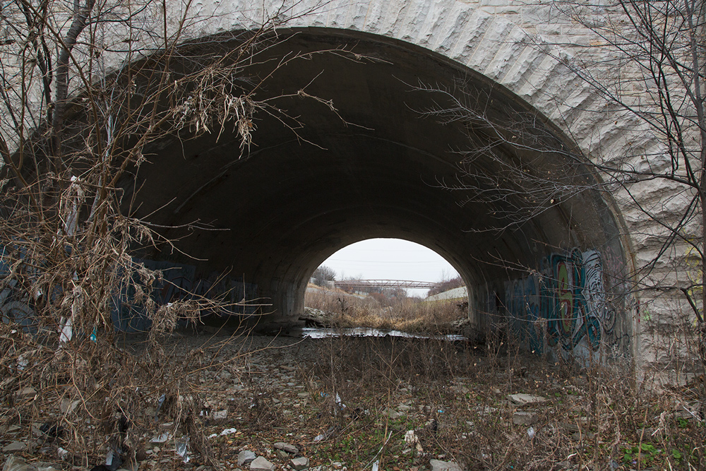
Tunnel to nowhere, Cambridge Woods
Bluff trail, Cambridge Woods
 
Grafitti, Cambridge Woods
 
The river, Cambridge Woods
 
Red sandstone cairn, Riverside Park


Monday, November 27, 2017

Thanksgiving at Cuyahoga National Park

-->

On Thanksgiving Day I found myself in the vicinity of Cleveland with a couple of hours to spare on my way to Pittsburgh for a family dinner. This was no coincidence. I have long wanted to explore Cuyahoga National Park, which is shoehorned into the densely populated region between Cleveland and Akron, OH. Talk about urban wilderness.

Ironically, since I-80 bisects the park, I have driven through it innumerable times on my way to and from the east coast. Until now, however, I have not taken the time to get off the interstate to see it. In other words, I have been as guilty as anyone of seeing the destination as more important than the journey. It was a great pleasure, even in this largely colorless season, to wander up and down the Cuyahoga River and get a taste for the lovely landscape.


Wikipedia has an entry for the term “urban wilderness.” However, the description of the “key traits” that constitute such a place could also describe any other kind of wilderness. It leans towards things like biodiversity, soil quality and an “unstructured aesthetic.” All important to the wilderness half of the equation, certainly. No mention, though, of the proximity or intrusion of a built environment.

As you can see from my photo essay, the built environment is a major component of the Cuyahoga National Park experience—as I see it.

In fact, one of the highlights of my visit was walking across the Brecksville-Northfield High Level Bridge, which—as the name accurately suggests—provides panoramic and breathtaking views of the Cuyahoga Valley in both directions. It does, that is, if you bother to get out of the car. Unfortunately, that is not encouraged. I had to park some distance away and walk along the road to get to it. Although the bridge itself had adequate shoulders, there were no trails or sidewalks approaching it from either direction.

I learned that the reason for this curious omission was probably deliberate. After only a few minutes of peering over the edge with my camera, a police car pulled up next to me. The cop asked me if I was “just taking pictures.” I smiled and said yes, but must have given him a quizzical expression. He informed me that this bridge was favored by those with suicidal tendencies. I assured him that it hadn’t occurred to me and he drove off.

I had already been thankful for the beautiful day and the remarkable park set aside amidst such surroundings, but Thanksgiving suddenly took on another and more profound level of meaning.


Add caption
Brandywine Falls, a major attraction
Brandywine Falls overlook
I-271 overpass