Thursday, December 10, 2015

Season's Greetings!

From the Lynden Sculpture Garden
2015 Artist in Residence

Sculpture: Salem 7, 1967, by Antoni Milkowski

May Peace settle like snow around you

and the Earth grow calm


I have had the privilege of serving as Artist in Residence at the Lynden Sculpture Garden this year. I am grateful to the staff there with whom I have worked. I've enjoyed meeting many other artists, some also in residence, some exhibiting, some leading workshops and others passing through. Most of all I have enjoyed the beauty and serenity of the place.

The mission of the Lynden Sculpture Garden is to promote the enjoyment, understanding, and appreciation of art and the environment. Public programming focuses on the intersection of art and nature. The setting integrates the Lynden’s collection of monumental outdoor sculpture with the natural ecology of the landscape.

The Residency Program is designed to enable artists to immerse themselves in Lynden’s sculpture collection, its landscape and the surrounding community. The residency program invites local artists to engage with the Lynden over a period of time, mostly commonly across four seasons.

To learn more about the 2015 residency and find links to many more images from the year go to the Lynden Sculpture Garden project page of my website.

Sunday, December 6, 2015

City Creatures: adventures in Chicago's urban wilderness


City Creatures: Animal Encounters in the Chicago Wilderness is a lovely new book published by the Center for Humans & Nature. The book consists of essays, stories, poetry and art and it is very much in the spirit of urban wilderness. I went to a reading today by co-editor Gavin Van Horn, Director of Conservation for the Center for Humans & Nature.


The reading was held at the Hal Tyrrell Trailside Museum of Natural History in Thatcher's Woods, River Forest, IL. Thatcher's Woods, which straddles the Des Plaines River, is part of the Forest Preserve system of Cook County.


I took advantage of the beautiful day to get to there early enough for a walk in the woods before the presentation.


The pond behind the museum was at flood stage following recent rains.


The leafless trees and swampy conditions made it easy to imagine wilderness today. But the sunshine was bright and cheerful and there were plenty of folks out enjoying it.

Des Plaines River.


The museum is barely visible through the trees.


Yes,  it's an urban wilderness.


I've forgotten his name, but the red-tail hawk lives at the Trailside Museum, along with a coyote, a couple owls, snakes and turtles. This poor guy was rescued, having lost one of his eyes.

A wonderful photo of another hawk graces the cover of City Creatures. I recommend it. If you're interested, check it out at the Center for Humans & Nature website.

There is also a City Creatures blog and--full disclosure--my work has been published on it.

Thursday, December 3, 2015

Hoyt Park: the trees lose again

Anyone who has driven anywhere along the Menomonee River Parkway in the past several months knows that it's being reconstructed a little at a time. Most of it is pretty much completed by now, except for one last stretch along Hoyt Park (where I happen to live!) One small component of the large project is the rehabilitation of the Hoyt Park pedestrian suspension bridge, which connects the park proper with Hoyt Park Pool. It will be a great relief to see those sadly needed repairs.


However, there's always a catch, isn't there? So often the catch is tree removal. And so it is with the bridge. I happened to be driving by yesterday and saw a crew lopping off limbs over the bridge. They were back again to day clearing more trees on the other side of the river.


Wednesday, November 25, 2015

Happy Thanksgiving!

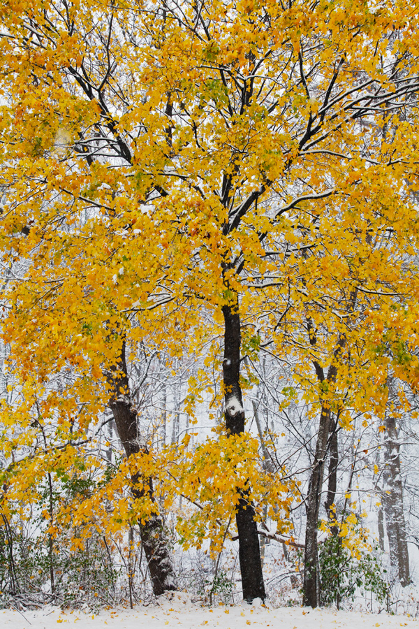
May your Thanksgiving be full of joy and companionship!


This cheery wintry/autumn scene is from Jacobus Park in Wauwatosa. The snow fell heavily on Saturday. While it was beautiful, I for one am thankful that the snow has largely melted and Thanksgiving Day tomorrow is expected to be milder yet.

Wednesday, November 11, 2015

Eschweilers to come down as Echelons rise: Photo essay

Followers of the Milwaukee County Grounds likely have already heard the sad news: At least two of the four historic Eschweiler buildings are to be "partially" demolished. The Mandel Group, which is in the midst of constructing their Echelon apartment complex in a ring around the site, has plans for all four. The former Administration building is to remain as a centerpiece to the Echelon development. The small engineering building may be converted into a single family home. The dormitory and dairy buildings are to be demolished down to the first floor. The remnants are to be re-purposed as "walled gardens."

There's more to the story, which was covered nicely and very thoroughly Striking An Imperfect Balance: Development, The Eschweilers & Monarch Butterflies .

I thought I'd add a few visuals to the story, so I went out yesterday and walked around the entire site to document the current situation:


The Eschweiler Administration building (left), which is to remain, and the northernmost apartment building under construction. View from Discovery Parkway.


The dairy building (background) has had its roof tiles removed. The interior is being gutted prior to deconstruction. The Administration building is on the right. New windows and roof tiles have already been installed.


The apartment building in the northwest corner of the site was the first to get underway and is the furthest along. View from the Monarch Trail.


Workers constructing one of the Echelon buildings (foreground) while other workers remove roof tiles from the Eschweiler dormitory building (background).


View looking southeast from the Monarch Trail of the Echelon complex (left) and the ABB building (right).


View looking northeast from the Monarch Trail of the Echelon complex.


Milkweed pod spreading its seeds on the Monarch Trail.

To see more photos of the County Grounds, go to my Flickr album

The Friends of the Monarch Trail and followers of the County Grounds have their eyes on another issue. The section of the grounds known as the east woods, which is located north of the power plant and Ronald McDonald House (see map below), has long been an area of concern as the last remaining segment that may or may not be preserved. I've written about it before, but there will be more to come.


Thursday, October 29, 2015

One Tree Hill, Auckland, New Zealand

-->
Its Maori name is Maungakiekie, the mountain of the kiekie vine. I didn’t notice any vines growing there. In fact, what struck me at first was the nearly complete lack of vegetation other than the closely cropped grass even on its steepest slopes. The reason for this was just as obvious. Sheep dotted the grass throughout the park, widely dispersed in some areas, clumped into small herds in others.


I’m trying to recall ever seeing a similar scene in an urban park. But I can’t.

There are trees in the park, but the native one (pōhutukawa, in Maori) that gave the hill its English name is long gone, victim of an act of vandalism by a white settler in 1852. Most of the non-native pines planted to replace it didn’t survive. Maori activists attacked the last remaining pine with chainsaws in 2000 as a protest against perceived injustices by the government. So, One Tree Hill bears no tree.

With only two days to see as much of Auckland as possible, we drove most of the way up to the summit. With more time and better weather I would have enjoyed the hike. We walked the last quarter mile in a light drizzle, sheep ambling out of our way as we approached. The cloud cover hung little higher than the summit itself when we reached it, which, along with the rain, limited the 360° panoramic views of the city and its two harbors.

One Tree Hill Domain, as the park is officially known, is one of a pair of conjoined parks (Cornwall Park is the other) that are situated near the center of the Auckland metropolitan region and the isthmus on which it’s located. Despite the inclement weather we were among quite a throng on the summit. In fact, there were many people throughout the large twin park landscape. I imagine it’s very crowded on beautiful days.


One Tree Hill is the remnant of an ancient volcano, one of 48 in the Auckland Volcanic Field. As we walked back down we noted the popular fad of using loose lava rock as movable graffiti down among the soft contours of the long-dormant crater. Without a few tiny sheep at the bottom it would be difficult to appreciate the size of the rocks or the scale of the mountain. Though far from a wilderness, One Tree Hill is a highly satisfying urban park experience.

This post is the second in a series from Australia and New Zealand. To go to the first, click on Muriwai Beach.

To see more photos from Australia and New Zealand, go to my flickr album


Tuesday, October 27, 2015

Dispatch from New Zealand: Muriwai Beach

-->
We’d been traveling in exotic places for so long, in two different countries and in several time zones, that the days of the week blurred together. But it was easy to tell that today was Friday. As it is with many a large city, the weekend traffic at 4:30 pm clogged the freeway leading out of town. As Auckland, New Zealand’s largest city, sits on an isthmus, the single route leading out into the countryside was predictably jammed.

An hour later, however, we were cruising along curving ridge top roads through a pastoral, peaceful countryside dotted with sheep and dairy farms. Finally, as we drew nearer the coast the road dropped into a luxuriant pine forest. Graeme, our host and guide, explained that the forest was a recent development. A hundred years ago the hilly landscape had been nothing but sand held in place by sand-tolerant dune grasses. A government program of progressive vegetation had proceeded gradually from nitrogen-fixing shrubs to today’s climax forest.

The forest provides a wide variety of recreational opportunities as well as lumber for harvest. We passed trailheads for hiking and mountain biking and a gated off-road vehicle course. But the vast majority of weekenders, like us, pass through miles of forest in order to access the beach.


Barefoot, we stroll through the last seaward stand of stunted, salt-bleached trees. Twin dunes loom above us. They must be at least 30-40 ft. high. We stand aside as a motorbike buzzes through the soft sand and away onto the beach. It disappears before we get there. There is no one else around.

Dark, volcanic sand and pounding surf stretches away as far as we can see and vanishes in brilliant, foaming mist. Amazingly, as close as it is to Auckland, Muriwai boasts 50 km (over 31 miles) of unbroken, undeveloped beach along with protective dunes and forested lands. Graeme tells us that recently the government ceded control of these public lands to the indigenous Maori people. I marvel at this, trying to imagine the U.S. government giving back to Native Americans, say, for instance, North Carolina’s outer banks or Cape Cod National Seashore.

We dip our feet in the crashing Tasman Sea, which reaches Australia over 2,100 km away. Very cold. (Much like Lake Michigan.)

The beach is popular for surfing, fishing, dirt-biking (as we noticed), horseback riding, and bird-watching. There is a notable gannet colony at its southern end, too far for us to reach today. Swimming is discouraged, however, due to dangerous rip currents.

No worries. Wandering, sinking our toes in the soft, black sand, soaking up the warm southern hemisphere springtime sun, and basking in the stiff onshore breeze are sufficient to fill us with contentment. 


Lynn and I spent almost 2 weeks in Australia and New Zealand. This is the first of a series of dispatches and photo essays from our trip. 

To see more photos from Australia and New Zealand, go to my flickr album