Milwaukee has earned the right to join the ranks of
Earth-friendly cities
 |
| North
Point Park |
Shrieking in my ear, the alarm wrenched me from sleep. 3:00
a.m. I often wake up to see the sunrise but this was unprecedented. The big
surprise, though, when I made it to North Point Park at 3:30 was the cheerfully
chattering crowd already assembled.
After a brief orientation, 30 of us set off in the sultry
night air to begin a 6-mile hike along Milwaukee’s lakefront. I was on my first
Brew City Safari, an enterprise founded
by Christian Matson-Alvirez. As we walked I asked him about his motivation and
purpose.
“I love Milwaukee,” he began, explaining that he enjoys
exploring the city and sharing his inclination with like-minded people. Then he
waxed eloquent about peace and tranquility. “It’s serene,” he says, “and you
don’t have to leave the city to have this experience.”
His elegantly simple words and the passion in his eyes
resonated profoundly. I felt as though he were reading my own thoughts.
We walked along the Oak Leaf Trail, through a tunnel of
darkness lit only by a flashlight and a communal idea: Milwaukee is marvelous;
let’s go for a hike and enjoy it!
Here was fresh evidence of an under-appreciated truth I’ve
long felt needs wider telling. For all its challenges—some real, some a matter
of perception—Milwaukee is a beautiful city with natural assets comparable to
any and human assets that stand above most. In many ways Milwaukee is a
farsighted ecological city and a model of sustainable urban living. Why don’t
we believe this of ourselves and make more of it?
 |
| View
towards downtown
from Milwaukee
River Greenway |
Amid unrelenting reports of global climate change and
environmental destruction it would be more than a good public relations
strategy to elevate Milwaukee’s status as a progressive, environmentally
conscious city. I believe Milwaukee can serve as a beacon of hope.
 |
| Cheryl
Nenn, Milwaukee Riverkeeper |
From the moment it was founded on the shore of Lake Michigan,
geography and the environment have played a huge role in Milwaukee’s history.
“Milwaukee is here because of its harbor and its three major rivers that run
like arteries to the north, south and west,” says Cheryl Nenn, who serves as
Milwaukee’s official Riverkeeper.
At first the rivers were for commerce and industry. However,
their value as an amenity that improves the quality of life for its citizens
was recognized far earlier than in most cities. In the early 20th
century, visionary leaders like Charles Whitnall endowed Milwaukee with a park
system that to this day is described in superlatives. Among its many qualities
the most ingenious was an emphasis on preserving parkland along the rivers.
 |
| Menomonee
River Parkway |
Consequently, Milwaukee’s many river parkways form an
“emerald necklace,” a term credited to the preeminent landscape architect, Frederick
Law Olmsted. While Olmsted himself designed three of Milwaukee’s parks—Lake,
Riverside and Washington—his principle of linear and linked parks and parkways
is his most important legacy. The concept of interconnected natural landscapes later
became fundamental to contemporary ecology and conservation.
The irreplaceable natural features of what is now known as
an Earth-friendly, “green” or Eco-city have been in place here in Milwaukee for
over a century. Today, however, acreage of open green space is not enough for a
city to be so designated.
I recently visited Portland, OR, which figures prominently
in most lists of Earth-friendly cities. I came away with three primary
impressions. First, the allure is real and the commitment to better the
environment is evident; most visible in their mass transit system and dedicated,
well-used bicycle lanes. Milwaukee is comparable in size but public transit is probably
our highest hurdle when it comes to sustainability.
Second, Portland has its share of problems. I saw people who
appeared to be homeless hunkered down in several inner city pocket parks. I was
cautioned against going into certain sections of the city, especially at night.
Portland’s poverty rate is somewhat lower but Milwaukee’s median income is
higher.
Most importantly, my visit to Portland convinced me anew that
Milwaukee has the potential to compete in this arena. Our most intractable
challenges are social. Poverty and racial segregation can never be dismissed. But
mostly what Portland has over Milwaukee is a belief in itself as an
Earth-friendly city. That belief—which attracts visitors like me and also helps
attract and retain a like-minded population—is neither insignificant nor easy
to replicate.
 |
| Lake Michigan shoreline at Doctor’s
Park & Schlitz Audubon Nature Center |
But we could be in their shoes. Grassroots groups like Brew
City Safari, along with far more established programs, prove that we are doing
the right things. Although often still considered a rust-belt city, Milwaukee
has made great strides.
There are many progressive initiatives and good-news stories
that suggest Milwaukee is more Earth-friendly than rust-belt. Here are five of
those stories, some of which have attracted national attention.
Revitalization of the
Menomonee Valley
Thirty years ago, the Menomonee Valley epitomized degraded
rust-belt deindustrialization. Today, thanks to the collaborative efforts of
government and private-sector leadership, the valley is a
nationally recognized model of integrated
economic and environmental revitalization. Guided by sustainable policies and
practices, new industries are moving back in amongst beautifully restored parkland
and some of the most popular entertainment venues in Wisconsin.
 |
| Three
Bridges Park, Menomonee Valley |
Milwaukee also is poised to replicate its successful
strategies in two other blighted areas: the Harbor District and the 30th Street
Corridor.
Urban Ecology Center
When the
Urban
Ecology Center, an innovative grassroots model of urban environmental
education, opened there in 1991, Riverside Park was shunned by neighbors. Its
Olmsted-designed features were all but obliterated by decay.
Since that time the Urban Ecology Center has opened three
branches, collectively serving more than 92,000 visitors with year-round
programming. Naturalists and environmental educators who want to emulate its
example travel to Milwaukee from around the country.
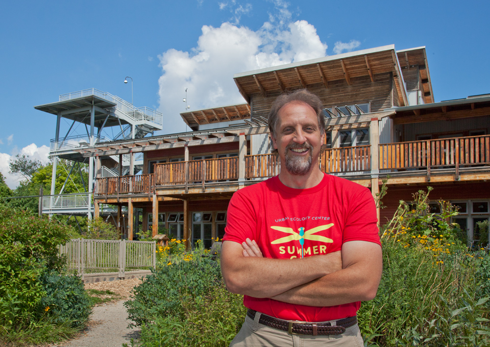
Ken
Leinbach, founder and Executive Director of the Urban Ecology Center (above), in front
of the Riverside Park Branch. “The fact that Milwaukee has two iconic
enterprises—the Urban Ecology Center and Growing Power—that grew from the
ground up shows the entrepreneurial spirit that exists in the city,” says Leinbach.
Riverside Park not only has been transformed into a lovely
and safe outdoor learning laboratory, but has expanded. The 40-acre
Rotary
Centennial Arboretum opened in 2013 on reclaimed post-industrial land.
Urban Agriculture
 |
|
Alice’s
Garden, located in Johnson’s Park |
Community gardening is not new, but today’s “foodie,”
organic and locavore movements have made urban agriculture trendy. Milwaukee’s
Victory Garden Initiative is an
updated version of a World War I wartime necessity, while
Alice’s Garden, with its
emphasis on youth empowerment, cultural development and sustainable practices,
takes the traditional community garden to a higher level.
 |
| Hydroponics
lab at Growing Power |
Milwaukee has actually been ahead of the curve on urban
agriculture since 1993 when Will Allen established
Growing Power. In addition to producing
high-quality, fresh and affordable food for inner city neighborhoods, Growing
Power
has become a national leader in urban agriculture through
its educational and technical assistance programs.
 |
| Will Allen with three young apprentice farmers |
Allen was honored with a MacArthur
Foundation “Genius Award” in 2008. “I’ve been in almost every city in
America and lots of cities outside the country,” he told me. “I feel that
Milwaukee is the urban agricultural capitol not only of the country but of the
world, because of all of the good things that are going on and all the
organizations that participate in urban agriculture and sustainable living.”
River restoration and
preservation
Milwaukee’s
rivers continue to be defining features. After a century and a half of abuse—when
they were dammed, lined with concrete and reduced to open sewers—the last forty
years have seen a complete reversal. Water quality has markedly improved thanks
to grassroots efforts of watchdog groups like Milwaukee Riverkeeper and mammoth infrastructure projects managed by the Milwaukee
Metropolitan Sewerage District (MMSD).
A widespread
appreciation for the natural qualities of rivers has replaced the conventional utilitarian
mindset. This shift is best symbolized by Milwaukee’s Downtown Riverwalk,
which literally reorients businesses and visitors toward the water.
 |
| Milwaukee
River Greenway |
The removal of the
North
Avenue dam in 1997 created an opportunity to develop the
Milwaukee
River Greenway and Overlay District. The Greenway unifies a diverse mix of
public parks and private natural areas and has become an exemplary place to
experience urban nature. The hard-fought Overlay District protects eight
miles of river, more than 840 acres of riparian habitat, and the “viewshed”
that enables visitors to have a virtual wilderness experience within minutes of
Downtown.
 |
| Kinnickinnic
River channel |
Nothing kills a river as thoroughly as
confining it in a concrete channel. In the 1990s, the MMSD systematically began
removing ill-conceived and outdated flood management channels to restore
waterways to more natural conditions. Major portions of Lincoln
Creek, a tributary of the Milwaukee River, and
the Menomonee
River already have been rehabilitated. A multi-year
project of the MMSD that began in 2012 is tackling the
Kinnickinnic River channel. What has been a dangerous drainage ditch will be
restored with a naturalized streambed, meandering watercourse and native
vegetation.
 |
| Restored section of Kinnickinnic
River |
The MMSD, in partnership with the
Conservation Fund, also has quietly
purchased over 3,000 acres of open land in the three watersheds. This “
Greenseams” program
is intended to prevent future flooding. Significantly, it also preserves land
for wildlife and recreation.
Water City
Remember Milwaukee’s marketing slogan, “A great place on a
great lake?” Today a far more ambitious and worthwhile initiative promotes
Milwaukee as a “water hub” for freshwater research, expertise and technology.
 |
| Global
Water Center & Reed St. Yards in Menomonee Valley |
The
Water Council,
formed in 2007 by business leaders, educators and scientists, touts a
formidable record of achievements and resources intended to put Milwaukee on
the world map. In 2013 the
Global Water Center
opened as an incubator for emerging water-related businesses. Milwaukee is one
of only 13 cities in the world that have been designated by the UN as a
Global
Compact City for the quality of its efforts.
 |
| Milwaukee
Water Commons' water celebration at Bradford Beach |
A more grassroots, community-oriented effort also has begun to
promote Milwaukee as a “Water City.” The
Milwaukee Water Commons holds
town hall meetings, partners with diverse community organizations to promote
sustainability, and hosts celebrations highlighting the importance of water as essential
to all life.
 |
| McKinley
Beach and a view of downtown Milwaukee at sunrise |
The sun rose over Lake Michigan when
our stalwart band of hikers reached Milwaukee’s popular beaches. I turned to
see the city bathed in the warm glow of dawning light, reflecting on how this
one small action fits into the larger picture.
 |
| Kevin Shafer at
the site of a restored section of the Kinnickinnic River |
Kevin Shafer, the executive director of
MMSD who has overseen major regional infrastructure projects, put it into this perspective: “It’s not just the government—it’s
everyone. It gets down to that individual person being more aware of what’s
going on, what they can do to foster this effort, for all of us to become more
sustainable.”
 |
| Sunrise
over Lake Michigan |
Much is happening on both levels, from infrastructure
improvements and land reclamation to simple hikes along the lakefront. We
walk because we love Milwaukee and it is beautiful. Milwaukee can be the
good-news story of urban development and sustainability. What we need now is to
believe it.
To see more photographs of many of the Milwaukee area parks
and natural areas go to Flickr.
An edited version of this story first appeared in my Milwaukee Magazine column online on Sept. 16, 2015.