Monday, February 6, 2017

Milwaukee County Grounds: A revealing winter walking tour demonstrates citizen concern


Open house at Wauwatosa City Hall invites public input on Tuesday from 5:30-7:30

“I heard that the city had changed its plans and will be saving the woods.” That was among the many comments I myself heard this weekend in a section of the County Grounds that some have dubbed “Sanctuary Woods.” I was talking with Dennis, who comes to the County Grounds almost daily to walk his two large dogs. Unfortunately,
--> Unfortunately, Dennis had heard something misleading—perhaps from an article in the Milwaukee Journal Sentinel—that depended on how “Sanctuary Woods” was defined. The current draft of Wauwatosa’s Master Plan would cut a road through the very spot we were standing, just like the previous version did. Dennis, like nearly everyone else I met, was surprised when he looked around at the area that would be destroyed.

The pavement on this popular pathway is a legacy of the asylum grounds that formerly occupied the site. This is where the road would go.
Fortunately, there has been an outpouring of concern about the fate of the County Grounds as well as the Master Plan itself. On Saturday a group calling itself Tosa for Good led a guided tour of the area that would be impacted by the proposed road. Despite a gloomy, overcast day, 50-60 people—including several city and county officials—endured frigid wind chills to walk the route of proposed “Scenic Drive.” The organizers had made the impact of the proposal more vivid by taping off part of the route in a 60-foot wide swath.

Caution tape indicating the width and route of the proposed road.
The tape made it clearly visible that the plan’s proposed 58-ft. wide right-of-way would obliterate a lot of natural land and require cutting plenty of trees. Virtually everyone who was there and saw firsthand what’s at stake agreed that the road should not be built.

Seven-story tall Harwood Place gives a sense of the impact that even taller buildings would have on adjacent woodlands.
When people are further informed that the proposed plan allows 10-story buildings to overlook the County Grounds there is universal astonishment. No one I spoke with wants this to happen.

The proposed road would cut a swath approximately four times as wide as this unofficial but well used neighborhood trail.
Starting at 87th Street the tour took the group east to a section of the grounds rarely included when people discuss “Sanctuary Woods.” But this combination woodlot and wetland that drains into the Menomonee River is the most secluded on the County Grounds. A trail well packed by neighbors skirts the woods on its way to the rest of the grounds. The proposed road would slice off a huge swath of the woods and create traffic through this bucolic corner of the grounds and around Harwood Place. However, the people who live in the adjacent neighborhood have developed an organized campaign that is generating more citizen interest and investment in the master planning process.

The proposed road would replace a series of warehouses along the railroad separating the County Grounds from Hoyt Park.


This wetland adjacent to “Sanctuary Woods” was isolated when the current roadway into the County Grounds was created.
Many of the tour participants had never been on the County Grounds before and no one wanted to miss the now-famous ravine. We entered the woods and followed the west rim. The packed earth trail indicates how popular this spot has become. There is apparently widespread agreement that the woods around the ravine must be saved. In fact, the master plan would protect it.

One of two stone staircases in bad disrepair that remain from the time this was a retreat for residents of the county asylum.
However, some who still want to build a road through this corner of the County Grounds have adopted the name “Sanctuary Woods” to justify the claim that it is being saved. In other words, the formerly undefined “Sanctuary Woods” is being defined by some to exclude natural areas that would be destroyed by the road. If built, a road would severely compromise the land as habitat and setting for peaceful recreation.

A lone jogger in the woods along the ravine.


As the tour passes the second of the stone stairs a couple of children break away to climb down and up again.

Beyond the end of the ravine several trails diverge and head uphill towards the rear of Ronald McDonald House. There are three meadows in the former asylum grounds. One is a remnant oak savanna, which is not only rare but also high quality habitat. The other two are hugely popular with dog walkers. All three would be destroyed by the road and development proposed in the plan. Two woodlots that many who use this land consider part of “Sanctuary Woods” would also be cleared.

The tour grouped around one of the entrances to the woodlot separating two meadows. This woodlot and both meadows are in the path of the proposed road.

The tour turned from the east meadow and headed back towards 87th Street, covering only half of the area that would be impacted by the proposed master plan. I returned the following day in order to complete the walking tour in photographs.

The meadow in winter
Humble as it may appear in winter with its matted grasses and dull colors, this meadow is what I consider to be the heart of “Sanctuary Woods.” It is spectacular in the summer when decked out in wildflowers and surrounded by giant oaks and maples; or in autumn when the leaves turn red and gold. Plus, this is excellent habitat for the birds, butterflies and small furry creatures that keep it spectacular. Unfortunately, the proposed road would run right through the middle of it.

The meadow in autumn
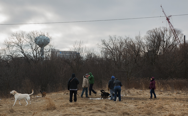
Dog walkers socializing on edge of County Grounds Park. The proposed road would go through the woodland in the background.

Sunday was as overcast as Saturday, but warmer. I met dozens of people. Most of them were out walking dogs of all sizes and breeds. Normally I keep to myself but this day I stopped frequently to chat. Without exception everyone I met had heard of the master plan. And all considered the road idea a mistake at best. Most used spicier language to describe the plan.

A small creek runs through the woodland, excellent habitat for a variety of reptiles and amphibians.
A man with a graying beard introduced himself as Tom. He told me he’d grown up in Wauwatosa and was incensed about the road. He’d seen plenty of changes over the years and he confessed that he had never been opposed to the flood detention basins like so many others had been. But this new master plan was going too far, in his opinion. He proudly whipped out his cell phone and showed me a photo he’d shot of a buck peering out of the undergrowth. “At least 6-point,” he said. “Could have been an 8-pointer.”

Danielle on her daily walk with her two dogs.
“It makes me angry,” said Danielle forcefully, referring to the master plan. “There’s so much wildlife here. If they put this road in here it will drive off the wildlife. Expect coyotes in your backyards killing your pets!” She explained how careful she was to control her two dogs so that they wouldn’t cause any harm.

The proposed road would begin at the roundabout next to the Marriott hotel at Innovation Park and run through this woodlot behind the power plant.
Two members of the Wauwatosa Common Council had taken the tour. Second District Alderman John Dubinski spoke with passion about the grounds. A retired police officer, he recalled fond memories of the County Grounds and especially the County Asylum buildings when they were still standing. “Now almost forty years later it is gone.” He enumerated the losses: beautiful brick buildings; an old red barn; baseball diamond; soccer fields; “and gone are all of the mature trees that shaded the area.”

Alderman John Dubinski: “I am strongly against the proposed road.”
“I will be taking my Grandkids for a walk through the wooded area north of the McDonald house, and taking many photos. It will be good to have a record of history should the wrong decisions be made.” When I asked specifically about the master plan he was unequivocal: “I am strongly against the proposed road.”

I counted eight owls on Sunday and I met two birders
who had driven from Iowa to see them.
In an email after the tour Third District Alderwoman Nancy Welch summed up the event: “I was impressed by the number of people from all parts of Wauwatosa who had taken the time to walk through the woods on a brisk Saturday morning. As I spoke to individuals along the way, it was clear that they valued the area, especially the ones who were experiencing it for the first time. Most conversations started with them telling me that elected officials should be listening to their constituents and doing more to protect the area. The conversation quickly turned to the quality of life that attracted them to this community and keeps them here. They were very concerned that protecting the Woods would require more than a promise to change the zoning, it will require changing the current focus on promoting too much development. I lingered after everyone left to appreciate the setting and was rewarded with the sight of a heron flying above the trees.”

Open house at Wauwatosa City Hall Tuesday, Feb. 7, from 5:30-7:30 p.m.

-->
This is an opportunity to ask questions, raise concerns and state your opinions about the plan.


More information available on the Wauwatosa website
To read the draft Master Plan, click here.


To see more photos of this area in other seasons go to Flickr.

An edited version of this story was published by Milwaukee Magazine on Feb. 6, 2017. 

Sunday, January 22, 2017

The specter of bulldozers on County Grounds floods Tosa City Hall with citizens


Though prevented from speaking the size of the crowd sent a clear message

Hundreds of people turned out Tuesday night to a normally quiet committee meeting for the unveiling of a proposed Wauwatosa master plan. Everyone in the room—and the overflow crowd in an adjacent room and out in the hall—they all knew why they were present.

An overflow crowd filled the Wauwatosa Common Council chambers Tuesday evening


Reacting to the prospect of bulldozers poised to plow through the County Grounds, which I addressed in my previous column, Mayor Ehley didn’t waste time getting to the point in her opening remarks, saying it is “untrue” that bulldozers would destroy Sanctuary Woods. Her words appeared to be calculated to relieve the anxiety of the audience. Although some in the crowd may indeed have been relieved, no one left the room. Promises have been made before about the County Grounds….

In fact, as the plan itself unfolded the headline of my story, “Wauwatosa master plan would bulldoze the last corner of the County Grounds,” was born out by a map (below), which shows not only the new “Scenic Parkway” (renamed from the last draft of the plan) but also a grid of new roads and new (potentially high-rise) development in the southeast corner of the County Grounds. Why the discrepency?

Detail of plan map showing “Scenic Parkway” and development options along both sides north of Ronald McDonald House.


As the mayor explains in an article in the Milwaukee Business Journal, “Sanctuary Woods” has “no strictly defined borders.” In fact, the name was conjured by the experience of those who enjoy its peaceful character and varied terrain. But the lovely name is also misleading—because it includes more than woodlands. The terrain that confronts the specter of bulldozers, according to this plan, includes critical habitat, small woodlands, and meadows that are particularly favored by wildlife as well as dog walkers. A small but significant wetland habitat would also be impacted by the proximity of “Scenic Parkway.” The planned extension of 92nd St.—for what purpose?—would further fragment an Environmental District that the plan itself identifies as “disjointed.” 

View of Sanctuary Woods: The plan would replace this humble gravel road with a paved thoroughfare dividing the woods from County Grounds Park.
The plan would protect the ravine. In the meeting as well as in an article in the Milwaukee Journal Sentinel, promises to save the ravine and "Sanctuary Woods" took front and center. The JS article makes it clear, however, that the mayor and planners construe Sanctuary Woods to refer solely to the isolated woodland surrounding the ravine and not to the adjacent meadows. Habitats are not so easily bounded. Unfortunately for the many people who enjoy those meadows as well as the wildlife that depends on the non-fragmented integrity of the whole, this plan would greatly diminish the intrinsic—if not the economic— value of the last unprotected sixty acres on this corner of the County Grounds.

One of three meadows popular with dog walkers, south of proposed “Scenic Parkway” that would see high-rise development in the plan.
In fact, although the justification for developing this natural space is to increase its economic value, the master plan itself recognizes both the appeal and the positive economic impact of parks and natural areas. In a section entitled “Money grows on trees” it says, “People like being close to parks and green space. Even if they are stalwart urbanites, the trees, flowers, shade, and breezes are alluring. Not surprisingly, property values reflect human desires to be near parks through an almost direct correlation between the adjacency of a home to a park and its corresponding property value.”

Plan cross-section showing Scenic Parkway and 6-story building looking out over the Environmental District.
The plan bears the academic-sounding title of “Life Science District Master Plan.” The District is quite large, extending from Wauwatosa Village on the east to Highway 100 on the west and encompassing all four quadrants of what used to be the whole Milwaukee County Grounds (until successive parts of it were sold and developed.) To its credit, the plan envisions reunifying the disparate segments divided by Watertown Plank Road and Interstate 41. The proposed result would be a mixed-use, high density “metropolitan center.”

The 150-page plan, complex and comprehensive, is admirable in many ways. It acknowledges historical origins of the County Grounds, analyzes contextual elements such as circulation, development patterns, and also existing parks and natural features. Plans for new developments throughout the district are outlined in detail. Density is one of the key concepts.

Master plan map of Life Sciences District
The Life Sciences District Master Plan does pay considerable attention to the environment. A stated goal is to “Adopt an Environmental Regulating Plan to preserve, conserve, and socialize the natural environment to guarantee the use of natural features for passive and active recreational use.” The mayor and planners all emphasize the importance of balance, a value I share. With regard to the Environmental District, the plan would benefit by adding the perspective of biodiversity and wildlife ecology to balance out its emphasis on engineering and trail development.

The largest section of the “Environmental District” is made up of flood detention basins.
The plan identifies and touts a 597-acre “Environmental District” as the second largest in the county (after Whitnall Park.) However, when alderman Welch challenged the validity of that claim by pointing out that the acreage includes such non-park-like segments as Wisconsin Lutheran College’s private athletic field campus, the crowd, which had been respectfully quiet throughout the presentation, broke into applause. It felt to me like a release of pent up tension as someone finally gave voice to collective doubt.

View of Milwaukee Co. Parks Administration building with trees cut for development of Innovation Campus in 2013.
What had brought us to the meeting in such numbers and had stirred doubts despite the mayor’s reassurances? Distrust of government is not limited to national politics. The people of Wauwatosa and beyond remember the compromises that have led to the loss of precious natural land on the County Grounds. People remember with horror when tree-cutting machinery did destroy a beautiful stand of mature hardwoods around the Milwaukee County Parks administration building—and still wonder why. People remember promises made to preserve the historic Eschweiler buildings. People are tired of fighting the now 20 years of compromises that have resulted relentlessly in loss of natural habitat.

Eschweiler-designed Dormitory building being deconstructed in 2016.
Let’s consider this suggestion as a compromise: the City could drop plans for “Scenic Parkway,” rezone all 60 acres that currently are non-park county land to give them preservation status, pledge to build no new roads in those 60 acres, request that the county add them to County Grounds Park, and reconsider plans to develop other natural areas within the District (such as at the Research Park.) I believe that such a promise, if kept, would help rebuild trust of City Hall enough that other, more laudable portions of the master plan—such as increased density, the circulator bus, and high-rise development in infill areas—would be subject to less intense, more amenable scrutiny.

There are other initiatives in the master plan that will concern residents of Wauwatosa. In fact, people have expressed concern that the fuss about Sanctuary Woods might serve to screen larger issues. Why, for instance, when there has been a veritable building spree—in the Village, at the Burleigh triangle, and elsewhere—does Wauwatosa need so much new, dense, high-rise development? And at the expense of the most precious commodity a community can own, it’s natural land. Can we concede a little more density to save the last unprotected natural section of the County Grounds?

Owls and other wildlife are threatened by planned road
During the presentation the assembled multitude was assured that the plan presented was a draft and likely to change after further public input. “It is my belief that at the end of this planning process, we will have a plan that balances environment preservation with economic growth opportunities, ” Ehley said. “A plan to protect beloved green space, as well as provide opportunities and guide decisions that foster economic development, job creation and added value.”

Let’s help her protect our beloved green space.

There will be a public open house on February 7, 5:30 -7:30 p.m., at Wauwatosa City Hall.

This time you will be able to speak.

Whether or not you can make the open house, please continue to make your feelings known to County Exec. Chris Abele as well as the Wauwatosa Common Council.

To conclude, the plan itself testifies as to why so many concerned citizens showed up for Tuesday’s meeting:

“When an area’s natural resources are conserved and protected while allowing for human socialization and activity, the users’ appreciation serves as a far more protective force than any regulation. A community’s collective will to protect a forest, prairie, or natural habitat is more powerful than a government-instituted zoning district. Rules can be changed and circumvented; the will of a united community is seldom negotiable.”

This entrance to Sanctuary Woods is in the path of the proposed “Scenic Parkway.”

Read it for yourself: Link to current Wauwatosa Master Plan.

See more of my photos of Sanctuary Woods on and the rest of the County Grounds on Flickr. 

A slightly edited version this story first appeared in my column at Milwaukee Magazine on January 19, 2017.

Tuesday, January 10, 2017

Wauwatosa master plan would bulldoze the last corner of the County Grounds

-->
Must “Sanctuary Woods” be sacrificed for retail and residential development?

I crept through the snowy woods as stealthily as possible, my eye on a tree limb ahead. Four long-eared owls perched on that limb stared back at my approach. As I raised and focused my telephoto lens one of them swiveled to confront me head on. Our eyes locked.

Long-eared owl
Then it and the others—including two I hadn’t noticed—rose and took off, sailing deeper into the woods. Six large owls! It was both a peak experience and a reassurance. I hadn’t seen any owls for several years and here was clear proof that they were back on the County Grounds in force. This was good news not only for the birders and others who love these woods, but it meant that the habitat remained healthy enough to attract an elusive and sensitive species.

Unfortunately, my reassurance was tempered by the realization that the very spot on which I stood watching the owls disappear from sight could soon be a road. If that happens they would likely disappear again, this time for good.

Sanctuary Woods has become a very popular place to walk dogs
For many, especially those who use this area regularly to walk dogs or simply to walk in the peaceful woods, it will probably come as a surprise to learn that this corner of the County Grounds has never been protected. It feels like parkland. In fact it was fenced off during years of construction all around it in order to preserve the habitat I’m witnessing now.

Construction fencing encircled the woodland during construction of County Grounds Park and the MMSD detention basins
But the decades of negotiation and compromise that resulted in the establishment of UWM’s Innovation Campus and adjacent County Grounds Park never involved this southeast corner. Now the City of Wauwatosa is developing a master plan that, in its current form, includes a new thoroughfare connecting Innovation Park with the Village of Wauwatosa. The 66-ft. wide right-of-way, which has already been named “Emerald Parkway,” would bifurcate the woods. A second, north-south road would separate the woods from the County Park, fragmenting wildlife habitats and diminishing the recreational experience for the public (see map).

Aerial view of County Grounds showing the approximate location of the new roads
The primary purpose of “Emerald Parkway” would be to spur dense, mixed-use developments (including residential and retail) along the entire length between it and Watertown Plank Road. According to a recent article in BizTimes, the County Grounds portion is just a small part of a larger plan to increase density along Watertown Plank Road, thus creating a new “metropolitan center” for the city. That larger plan has merit.

Stepping back from the County Grounds for a moment, an overall increase in density ought to be good both for economic development and conservation of wildlife habitats. As global populations become increasingly urban and therefore more distant from surrounding nature city planners all over the world are taking up the challenge of providing urban parks as an antidote. Density is part of the solution—as long as the density doesn’t destroy irreplaceable natural areas.

The stub of a new road already points east from Innovation Park towards the threatened woodland
You don’t have to be a nature-enthusiast to see that parts of Wauwatosa’s plan fly in the face of conventional wisdom. Parks improve the quality of life for a community’s residents. But also, from a purely pragmatic point of view, it is well documented that property values (and therefore potential tax revenues) increase near parks and natural areas. Parks create value. They are also an attraction. On its website, Discover Milwaukee, a business-oriented organization, describes Wauwatosa as “attractive to professionals because of its proximity to the Milwaukee County Grounds” [emphasis theirs].

Although it has no official designation, the southeast corner of the County Grounds has come to be known colloquially as “Sanctuary Woods,” a hopeful appellation. The location, adjacent to the Milwaukee County Regional Medical Center makes it ideal, in its current natural state, for a health and wellness trail. "Proximity to nature is a valuable asset for the medical complex," says Dr. Marc Gorelick, pediatrician and Executive Vice President at Children's Hospital of Wisconsin. "The natural beauty of the County Grounds is important to patients and families, who see it as a peaceful refuge at a time of great stress. It is also increasingly attractive to our workforce, many of whom are millennials who value environmental conservation. Given the existing high density of development on the medical campus itself, any further loss of green space on the remainder of the grounds would be very concerning."


Stone stairs still lead down to the ravine trail from the time when the County Asylum was located here

Sanctuary Woods, which includes a meadow, wetland and a rare remnant oak savanna, is one of the more beautiful and bio-diverse sections of the County Grounds and therefore—not surprisingly—intensively used by the public. “It is safe to say that, if you polled the neighborhoods around the County Grounds, you would find resounding support for preserving this wildlife habitat,” says Bryan Lenz, Director of Bird City Wisconsin [emphasis his].

Wauwatosa, which prides itself on being a Tree City USA, has yet to be designated as a Bird City. But it could. In a passionate letter opposing the proposed road Lenz describes the importance of such natural areas to humans and wildlife and says that the County Grounds has “one of the largest bird lists” in Milwaukee County. He goes on to say that the road and subsequent developments would cause fragmentation of habitats and “destroy its value for sensitive wildlife.”

A very healthy cardinal wintering in the County Grounds
It’s probably safe to say that those at City Hall who want to see this road built will not be polling the neighborhoods to learn how much the community loves this land. However, there will be an opportunity for public input. An updated version of the master plan will be presented to the Wauwatosa Common Council’s Committee of the Whole at 6:00 p.m. on January 17. That meeting is open to the public (at Wauwatosa City Hall, North Ave. and 76th St.). After that meeting a public open house will be scheduled for sometime in early February, according to Paulette Enders, City of Wauwatosa Development Director.

In the meantime, you can always contact the Wauwatosa Common Council, the mayor’s office and Milwaukee County supervisors to voice your opinions and feelings. Although the City of Wauwatosa is developing the master plan, the land is owned by Milwaukee County. In a resolution passed in October 2016 the county board requested an environmental assessment specific to the proposed road be done by March 2017.

A snowy morning in Sanctuary Woods
On a recent morning as I walked again through Sanctuary Woods I met a man named Mike whose two large dogs ran circles around us as we chatted. He echoed my love for the woods. When I mentioned the proposed road he grew solemn and told me, “I used to walk my dogs around the abandoned Eschweiler buildings, until they built apartments there. I figure this here is the last corner left that’s natural and peaceful. Seems like they just want to tear everything up.” I assured him that there are many people who feel the way he does and expressed hope that “they” can be convinced to save Sanctuary Woods.

As he turned to go he said he’d contact his aldermen.

See more of my photos of Sanctuary Woods on and the rest of the County Grounds on Flickr. 

This story first appeared in my column at Milwaukee Magazine on January 9, 2017.


Saturday, December 31, 2016

2016: The year in review

Interstate Falls, Iron County, WI, on the border with Michigan's Upper Peninsula
It was a remarkable year in the Urban Wilderness. Grateful for the opportunities, the year took me to some lovely new places, allowed me to revisit some of Wisconsin's great places, and even to explore a few new places (to me) right here in Milwaukee. Follow the links in each excerpt to read the whole story and see the photo essays.

The year began with a blast--of cold that is. I went to New York just in time to witness the city shut down for the blizzard that dumped a record-breaking two feet of snow in one day. It was great fun to walk down the middle of 9th Avenue in the snow and even more fun to join thousands of like-minded New Yorkers romping in Central Park. The blizzard obliterated the surrounding city, making Central Park more of an urban wilderness than usual. Making the best of the New York blizzard.

Later in January it was a distinct pleasure to be introduced to the Flying Squirrels in the Milwaukee County Grounds, right in my backyard! Turns out they are native to the area. However, since they are elusive and nocturnal I would never have seen one if not for a chance encounter with Gary Casper, the scientist who is monitoring the squirrels and who took me on a tour of the nesting sites.

In February the wilderness came indoors when the Milwaukee Art Museum opened an exhibit called Nature and the American Vision: The Hudson River School. My review.

In March I drove to Houston, Texas for a conference organized by The Cultural Landscape Foundation. Stopped in St. Louis on the way where their version of New York's Central Park is called "Forest Park." I found it to be more urban than wilderness, but lovely.

The theme of the Houston conference was "Leading with Landscape." I learned a lot about Houston not only from the conference itself but from the two days of guided tours that followed. I also learned that Milwaukee has long had a head start when it comes to preserving and enjoying its landscapes, aka parks and natural areas. I wrote an essay about that for Milwaukee Magazine called What can Milwaukee learn from "Houstonization?"

Buffalo Bayou Greenway, Houston, Texas

In April I took a much shorter road trip to visit Chicago's Millennium Reserve for the second time. The Millennium Reserve Initiative, still in its infancy, is intended to create a network of parklands that in total would be the largest urban park system in the country. Much of the system would be comprised of rehabilitated brownfields and post-industrial landscapes sprawling across Chicago's southern edge and into Indiana. Millennium Reserve: visiting Chicagoland's ambitious urban wilderness project.

In May I sought out signs of spring in Milwaukee area parks and found a LOT! I posted four photo essays of my explorations:
Cudahy Nature Preserve: bursting with spring
World Fish Migration Day at Riveredge Nature Center
Mangan Woods blossoms with spring
Review of springtime in Milwaukee (Yes!)

In July I discovered that a new trail had been added along the north bank of the Menomonee River across from Three Bridges Park in the Menomonee Valley. North Bank Trail.

On August 7 the Milwaukee Water Commons held its third annual We Are Water celebration on Bradford Beach. So began a month of water, nature and park-related events.

Citizens Acting for Rail Safety held its second annual Rally on the Milwaukee River to protest oil trains.

One of my biggest adventures of the year was a kayaking expedition with three other river rats down the Menomonee River, my home turf. The projected three-hour tour turned into a six-hour ordeal that we all loved: The constant lure of adventure: Kayaking a surprisingly wild urban river.

Kayaking the Menomonee River, Wauwatosa, WI

August 25 marked the 100th anniversary of the founding of the National Park Service. Since the Indiana Dunes National Lakeshore is the closest national park to Milwaukee, I went there to pay tribute: National Park Service turns 100.

On Sept. 11 a water-related service at my church inspired this reflection: Water Communion.

September also saw a gratifying resurgence of monarch butterflies along the Monarch Trail in the Milwaukee County Grounds. In what began as an act of faith with no assurance of success, years of lobbying to preserve land and efforts restore habitat seems to be paying off as more butterflies roosted this year than in any of the last ten. Monarch return in force to the Monarch Trail.

In October I went a little crazy.

The month began with a guided tour of the Penokee Hills region of Northern Wisconsin and Michigan's Upper Peninsula. A selection of photos from that trip are on a Flickr album.

When I returned from up north the unrelentingly beautiful autumn led me to spend nearly every day outside in one or another of the Milwaukee region's remarkable parks and natural areas.

If you haven't heard of Brew City Safari, I recommend this hiking club. I went on two hikes with them in October:
Milwaukee River Greenway
Havenwoods State Forest

And it took a whole series of posts to share my experience of autumn in Milwaukee:
Greenfield Park: A walk in the woods
Grant and McGovern Parks
Cudahy Nature Preserve and Falk Park
Humans and Animals: Lake Park and Schlitz Audubon
A magnificent autumn in Milwaukee's parks

Grant Park beach, South Milwaukee, WI
Although autumn slipped into the beginning of November, it wasn't long after that when the season changed. The first day of December found me in Racine, exploring a park I'd never been to before:
Quarry Lake ramble: photographs and poetry was the result.

If you've never seen the Santa Rampage and if you missed my post the first time, you definitely want to check this one out.

When the snow finally showed up I went back to Greenfield Park and to Havenwoods State Forest to be out in it: First snowfall.

The last two weeks of 2016 found me in the most exotic location of the year, Nicaragua. While wilderness eluded me I enjoyed beautiful flowers everywhere I went. Urban Wilderness in Nicaragua, just posted yesterday after my return.

And so ends 2016. If only the political landscape had been as beautiful as the natural one!

Here's to 2017, may it bring humility as well as accountability, peace and determination, greater cooperation but never tolerance of hate. May we live sustainably and spend time in nature frequently whether we live in a city, suburb or rural area.

Greenfield Park, West Allis, WI


Friday, December 30, 2016

Urban Wilderness in Nicaragua


I've been AWOL for a couple of weeks. But I have a good excuse: I've been out of the country. In Nicaragua to be exact. Over the past ten years my wife, Lynn, has developed a regular working relationship with a non-profit organization in Managua called Cantera. The mission of Cantera is to build a more just, equitable and sustainable society through holistic community development using the methodology of Popular Education. This year Cantera invited me to accompany Lynn in the capacity of artist in residence for a two-week period. We just returned last night.


Managua has little in the way of urban park infrastructure, but I managed to make a few photographs that I hope capture a little of the yin and yang of Nicaragua. On the one hand it is a tropical land with abundant natural beauty and on the other it is the second poorest country in the western hemisphere (after Haiti.) Here is a here is one of two initial selections of photos. The other set can be seen on my Arts Without Borders blog.


 The sign overlooking Lake Managua (which is severely polluted) reads "respect Mother Earth."

To see a different selection of photos from the residency go to Arts Without Borders.