Showing posts with label mmsd. Show all posts

Sunday, July 10, 2016

Menomonee River reconstruction nears completion


The limestone rip rap gleams in the hard mid-day sun, a beautiful sight to see. And, yes, I think it will look even better after a few years, when vegetation grows through and over it, softening its hard edges and obscuring the gleam of the white stone. But this corrective measure has been years in the making and it's good to see it nearing completion.


This one short section, right next to the Wisconsin Avenue viaduct, is all that remains of the concrete channel that was installed in the Menomonee River between the stadium and Miller Brewing in the 1060s as an ill-conceived and ultimately ineffective flood mitigation strategy. To read more about the project go to the MMSD website. To see my previous post, a photo essay showing the beginnings of this phase of the project in 2015, click here.


Meanwhile, the Kinnickinnic River project, which will remove even more concrete from that much more maligned waterway, is underway and projected to be completed in 2022. If you haven't seen it yet, my exhibit, Concrete River: Memorial and promise on the Kinnickinnic, is still on display at the Alfons Gallery through July 31. For more information, click here.


Thursday, May 21, 2015

The Kinnickinnic River and community development: A makeover


--> -->
A south-side community fills a void created by flooding

The truck that was to deliver the flowers was late but no one seemed to mind. Neighbors chatted amiably in Spanish. Staffers from the Sixteenth Street Community Health Centers had set up two tents for an annual spring plant sale. The tents and the people milling around them seemed very small in the broad, vacant city block between the Kinnickinnic River and the row of houses fronting W. Harrison Ave .


Propelled by several impatient children, a few people went across the vestigial dead-end street to the adjacent city block, also largely vacant. Raised beds for community gardens had been built and fenced in a small corner of the block. Volunteers showed the kids how to pull weeds and rake the soil in preparation for planting. Incrementally, the community is reclaiming empty land that stretches four long city blocks alongside the river. 


Not long ago all of those blocks were filled with houses. The 
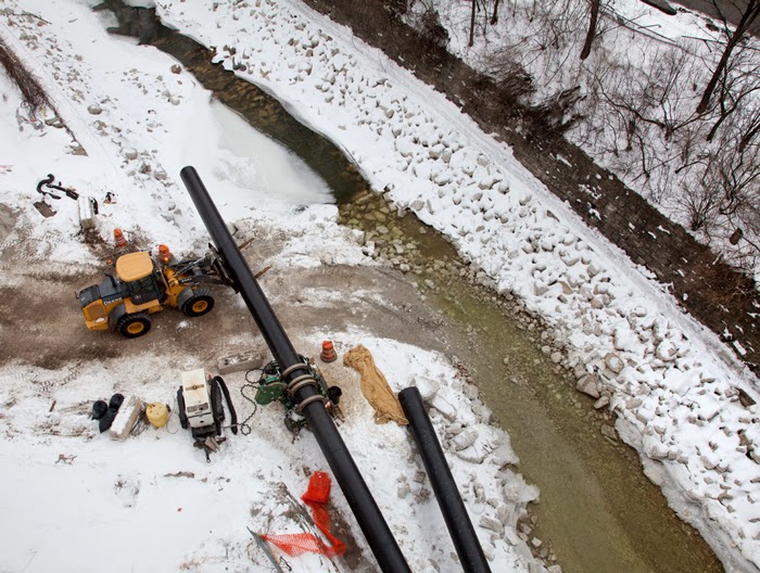
reason for their removal is as concrete as the river that bisects the neighborhood. The Kinnickinnic River has literally been lined with concrete since the 1960s. It looks more like a drainage ditch than a river. This was no accident. At the time it was believed that channelization would solve the problem of flooding.


Today the channeled river seems more like a catastrophe than a solution. While the drastic measure did reduce flooding for a time, it also degraded water quality, destroyed all semblance of wildlife habitat within and along the waterway and increased the threat of drowning. Now, ironically, even the original intent of the channel is no longer effective. The past 50 years has seen the floodplain rise dramatically. If nothing were done to alleviate the new circumstances, a major storm could inundate as many as 350 homes in the neighborhood.


Which is why the houses have been purchased and, one by one, dismantled. The removal of the houses is just part of a major flood management initiative led by the Milwaukee Metropolitan Sewerage District. Sixteenth Street Community Health Centers and partners have been implementing quality of life improvements from a companion plan called the Kinnickinnic River Corridor Neighborhood Plan. The most dramatic and eagerly awaited changes—the removal of the concrete channel and rehabilitation of a naturalized river—will come later. The most trying task is currently underway: asking families to move and tearing down houses.


Over 60 homes have already come down. Hence the vacant land. Last week I was able to observe the workers as they dismantled another. Although more expensive than traditional demolition, the MMSD has opted for a process called deconstruction. Forgoing the bulldozer for manual labor, everything salvageable or recyclable is painstakingly removed from the house. Usable appliances and fixtures are set aside. Plaster walls are pummeled until they reveal the lathe and studs beneath, which become recycled wood.


House demolition usually generates a huge amount of indiscriminately crushed debris that is hauled off to landfills. The more laborious deconstruction process enables materials to be separated for recycling and reduces what ends up in a landfill.


The process began here years ago. Numerous neighborhood meetings were conducted to explain the project and build community support. Initially, there was concern and hesitation about the acquisition and removal of homes. However, now that the work has progressed as far as it has the mood has shifted. According to Iris Gonzalez at the Sixteenth Street Community Health Centers, many people have become not just supportive but excited about the project. There is even some impatience at the pace of the work.


As more houses come down and more land stands vacant, people have begun to imagine its eventual transformation. They anticipate the planned new parkland and an actual river running through the neighborhood. The project is supposed to be completed in 2022.


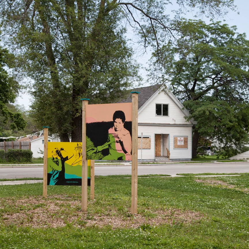
Meanwhile, the neighborhood has begun to fill the void. In addition to the community gardens some temporary public art has been erected on another corner of cleared land.


I wander back to the tents. The truck has arrived. A crowd gathers to help unload the plants and get them ready for sale. People are lined up to make their selections. The Sixteenth Street Community Health Centers staff is joined by young volunteers who help carry potted flowers back to cars and nearby homes. The annual event is called “Bloom and Groom.” It is subsidized by the collaborative efforts of Urban Anthropology and Sixteenth Street CHC along with grants from the Greater Milwaukee Foundation and the Neighborhood Improvement Development Corporation. The organizers hope that investing in flowers and improving the appearance of the neighborhood will be a visible demonstration of pride and commitment to the future.


The flowers are beautiful in the bright morning sun and the smiles on everyone’s faces, it seems to me, are a clear sign of that hope and pride.

To see more photos from the KK River and the neighborhood go to my flickr album.

If you missed my recent post about the Earth Day clean up of the KK River, click here.

Full disclosure: I am connected to the two lead organizations responsible for the KK River Flood Management Project and Neighborhood Plan. I am working with the MMSD to document the current phase of the KK River Project and until recently my daughter was employed by the Sixteenth Street Community Health Centers. But if you check out my flickr photos it will be clear that I've been interested in this work long before any of that!

Friday, February 13, 2015

Last stretch of concrete to be removed from Menomonee River


Preparation is underway for the removal of the last section of concrete channel from the Menomonee River. The project area runs from the Wisconsin Avenue viaduct through Piggsville to Miller Park. The current work being done is to install two diversion pipes along the sides of the existing channel. These pipes are intended to carry the flow of water during demolition and reconstruction.


New sections of pipe are attached at the upstream end of the line (above). After being welded together, the entire pipe must be dragged downstream by this tractor (below), which can pull the 200,000 lb. load.


At the downstream end of the line, just past the I-94 overpass, ice is being removed from the channel.


When completed the concrete channel will be replaced with rock, as was done with the previous stretch, which was done in 2013-2014 (below). To see a previous photo essay of that project, click here.


The purpose of the channel reconstruction is to remove the outdated, ineffective flood control channel, return the river to a more natural state and enable fish to migrate freely. To read more about this project, go to the MMSD website.

Wednesday, December 11, 2013

Common Ground sponsors tour of MMSD

-->
 
 The photos are mine, but the text that follows was written by Pete Overholt, who organized the tour we took on behalf of Common Ground.
 “Did you know the deep tunnel has close to 30 miles of water storage capacity?  Did you know leaky laterals – the pipes that connect our homes to the sewage treatment system - are a significant problem during large rain events?  Did you know you may be eligible for a mini-grant to help pay for installation of a rain garden on your property?  Did you know one of the major tools for water treatment is microbes … that “gobble up” contaminants?  Did you know that Milorganite is short for “Milwaukee Organic Nitrogen”? 
A bus-load of Unitarian Universalists learned all this and a lot more during a tour of the Milwaukee Metropolitan Sewerage District (MMSD) Jones Island wastewater treatment plant on Saturday, 12/7.  Clouds of vapor rising from settling ponds set against crisp blue sky provided a dramatic backdrop for the event, and our guides did a great job of fielding a steady stream of questions. Our group followed the process from trash filtering to settling, through the microbial buffet and chemical cleansing, to final discharge of clean water to Lake Michigan.
The operation was impressive, but there is always room for improvement.  While sewer overflows are a much smaller problem than they were in the past (thanks to deep tunnel storage capacity), they still occur, and urbanization continues to add impervious surface, increasing the volume of water that must be handled.  Individually, we can all have an impact; if it’s raining hard, shorten your shower, and save laundry for another day!  Collectively, MMSD gave us a picture of sanitation and storm water handling in our community.”
Common Ground is a nonpartisan organization in Southeastern Wisconsin dedicated to identifying pressing social problems facing our community and bringing about creative solutions. To learn more about Common Ground, go to their website.
The interior shots are all of the drying facility that makes Milorganite, which is used as fertilizer.
The Jones Island stack is 300 feet tall, which is also how deep the deep tunnels are.

Full disclosure: I attended the tour as a member of Unitarian Universalist Church West.

Saturday, July 23, 2011

Underwood Creek: good, bad, and ugly?


Underwood Creek has long been a troubled waterway. Much of it was channelized in the 1960’s, as is most dramatically evident in this view west from 115th Street in Wauwatosa. Now Waukesha  wants to dump its (treated) wastewater into Underwood Creek – from whence it would flow into the Menomonee River.


If you’ve been following this issue you know that the diversion of Lake Michigan water over the boundary of the Great Lakes watershed has been highly controversial. Although the Wisconsin DNR recently approved the application process, allowing it to move forward, the decision still must be ratified by the governors of all states (and provinces) that border on the Great Lakes, in accord with the Great Lakes Compact.

I urge everyone to attend one of three public hearings that have been scheduled for southeastern Wisconsin to give the DNR a chance to provide an overview of this process.

One of the public hearings is at 5:30 on Wednesday, July 27, at Hart Park in Wauwatosa.

The other two are in Pewaukee (July 26) and Sturtevant (July 28). For much more information about the issue and all three public hearings, go to Milwaukee Riverkeeper.


As part of the Milwaukee Metropolitan Sewerage District’s flood management project, a lot of time, effort, and money have gone into removing a section of the concrete channel from Underwood Creek. The benefits of this are far more than aesthetic. This photo shows part of that work in progress in 2010. What will happen to all of this when the extra wastewater from Waukesha in thrown into the mix? I hope the public hearing will shed some light on that and many other questions.
Other things are happening along Underwood Creek. On the plus side, I recently biked underneath Bluemound Road on the Oak Leaf Trail for the first time – a huge improvement, as anyone who frequents this popular bike path can attest. As this photo shows, there is still some work to be done before the new path is completely connected on either side of Bluemound. 
On the unfortunate and ironic side, a section of Underwood Parkway, near Watertown Plank Road, is being repaved. I’m all for new pavement. This parkway has been getting progressively worse for many years. But why are they putting in curbs?
Progressive streetscaping uses swales instead of curbs. Swales are gently sloping ditches that allow stormwater to soak into the ground instead of running along the curb and into a sewer pipe. They are a perfect solution for a roadway like the parkway. How much taxpayer money has gone into flood management on both sides of this parkway, along Underwood Creek and in the County Grounds? But now we’re putting in new curbs and sewers to carry off stormwater instead of inexpensive swales?

Sunday, May 1, 2011

County Grounds public hearing Monday May 2

Monarch Trail and Innovation Park site
I am forwarding the following announcement from the Friends of the Monarch Trail. I hope you will join me and give your input at this important meeting:


The City of Wauwatosa is hosting an open house for public input regarding trail connections on the County Grounds – Monday, May 2.

May 2nd –   4:30 - 7:00 pm
Wil-O-Way   @  Underwood Parkway

10602 W Underwood Creek Parkway (across from Hanson golf course)

Please come share your ideas for the “master trail plan” that is to be implemented by the National Parks Service. Several parcels that are owned and must be maintained by different agencies will have trails, including the State Forestry Education Center, the new Milwaukee County Park, and the MMSD detention basins, as well as the UWM Innovation Park complex.

The Friends of the Monarch Trail have worked hard to preserve the Monarch Trail, the butterfly habitat, and the natural environment on the County Grounds. Now is the time to get the Monarch Trail on the official Map! We thank you for being persistent in your efforts to preserve this critical habitat~
  
**Brief presentations describing the project will be given at 5:00 and again at 6:00 pm 

Please take time to stop in wherever you can fit it in between 4:30 and 7Pm. This is the one chance to show our interest in the Monarch Trail and how it will connect with the rest of the trail system being created on the County Grounds.
  
Talking points to comment on:

·        End results should provide first and foremost for the needs of the habitat; this is the main attraction and the reason for the Monarch Trail.

·        Connecting the Monarch Trail to the other trails will make them all more successful because it is and attraction and highlight that stimulates curiosity and interest.

·        Mention possible negative impacts along with solutions.  The 11-acre monarch habitat is too small to accommodate paved paths or room for bicycles. The idea for this segment of trail is to provide a peaceful place for observation, photography, and not a tract for commuting through; a good comparison would be Wehr Nature Center. There are areas for tramp trails and more appropriate places for bike trails.
There will be thoroughfares for bicycles and vehicle access to the habitat via the residential roadways and parking lots.

·         Preservation of the natural scenery to provide views is also an attraction as well as the historical features such as the Eschweiler buildings. All planning of trails that is not in keeping with the scenery or which would obscure, distort, or detract from the integrity of the environment should be avoided. The trails are for humans, but the environment comes first.

·         The wildlife and ecosystem depend on our protection. The trails should be integrated in a way that enhances and protects the landscapes that support wildlife.

·        Promote the need to preserve the woods behind the Ronald McDonald House as part of the trail system. Milwaukee County should retain these valuable woods in order to reconnect the environmental corridor. 


Metaphor? I hope not.

Thursday, February 24, 2011

Kinnickinnic River views

Last week, during the heat wave, the rivers revealed much that had been buried under ice and snow. Here are a few snaps from the section of the KK that is part of the MMSD flood control project, between 6th Street and 16th Street. (The concrete channel is to be removed and the river reconfigured.)


Santa caught in the stream.


View west from 6th Street, with Santa Claus.


No words needed.


One of the houses on the list for demolition.


The slabs of ice struck me as appropriate metaphors for the slabs of concrete that will soon be removed from the KK channel. (In 2008 the KK was designated one of the ten most endangered rivers in the country. Federal funding for mitigation followed, thankfully!)

For more images of the KK River, go to my flickr page.

Wednesday, September 22, 2010

Green Rivers

Do you know what color your river is today?

I had read that the the sewers were being tested, but it still came as a shock when I happened upon the acid green waters in a neighborhood creek that carries run off into the Menomonee River. I imagine that anyone who didn’t know what was happening would be more than shocked. In fact, I’ve gotten emails from folks that were disturbed as well as curious. (I guess I’m ready-reference now for the rivers! I’m flattered. But, for anyone who doesn’t already know this, the person who really knows all about this stuff is our Milwaukee Riverkeeper, Cheryl Nenn.) The obnoxiously bright green is harmless dye deliberately introduced into drains by the City of Wauwatosa to detect what is called infiltration and inflow, which is supposed to help them track down where actual pollution is coming from. I hope it works!


To read a Milwaukee Journal Sentinel article about the testing and the flooding that precipitated it, go to "Tosa sewer test finds big leaks in home laterals."

For more information contact Milwaukee Riverkeeper.

Monday, June 28, 2010

Good news today for the urban wilderness - Greenseams!

If you've never heard of Greenseams check it out on the MMSD website. Briefly, it's a program to help reduce flooding by protecting natural areas from being developed. For several years MMSD has been buying thousands of acres of land, mostly in the outlying areas of the Milwaukee watersheds in the MMSD service area.

It was in the news today because another property was purchased, this time along the Little Menomonee River in Mequon. Read the story in the Milwaukee Journal Sentinel.

This image is from an earlier Greenseams purchase
and was included in

Tuesday, June 15, 2010

Milwaukee's Kinnickinnic River gets a well-deserved makeover


Not long ago the KK River, as it is called locally, was designated one of the ten most endangered rivers in the country. Not long after that federal money became available allowing for the beginning of was is hoped will be long-term improvements, which was the main point of the designation.

There was a nice story in the Milwaukee Journal Sentinel last week about a major improvement project that is underway by the Milwaukee Metropolitan Sewerage District. Check it out at "Kinnickinnic River Reclaims Banks."

If you want another analysis of the project, including a map, go to Great Lakes Water Institute.

For more of my images of the KK, go to my flickr page.